Mu Ko Chang National Park
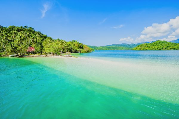
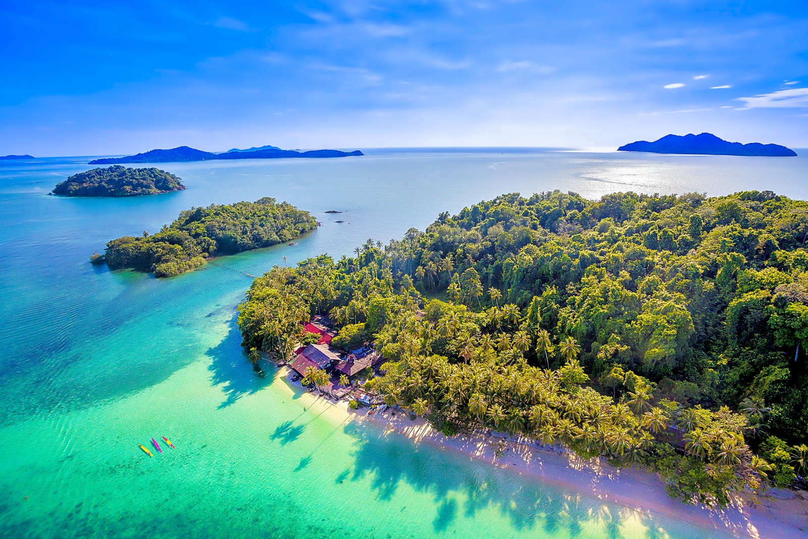
Ko Chang is an island where the weather is not too hot or too cold since it is affected by both Northeast Monsoon and Southwest Monsoon. The influence from those monsoons leads to the traveling restriction by boat. That is, during the Southwest Monsoon or around May to October, the West Coast, the windy side, often brings strong winds; therefore, it is not the best time for traveling. However, November to May is the least windy time in the year so the trip to Ko Chang or other islands is quite convenient. Mu Ko Chang national park is 650 square kilometers, consisting of 52 islands lining up from Amphoe Laem Ngop, Amphoe Mueang, to Amphoe Khlong Yai. Apart from the most important island– Ko Chang, the other islands like Ko Khlum, Ko Lao Ya Nai, Ko Ngam, Ko Mai Si Yai, Ko Wai, and Ko Rang still remain their natural beauty. The National Park Office is located on the east of Ko Chang, near Khlong Than Mayom. The National Park’s large harbor is situated at the front of the office. There are also three places of National Park Service Ranger, all of which are on Ko Chang-at Ao Khlong Son, at Namtok Khlong Plu entrance, and at Salak Phet Village.In the past, there were no settlements or residences on the island. The island was important as a harbor for sheltering from the monsoon and a source of provisions and freshwater. Ao Salak Phet and Ao Salat are very well-known among the pirates, Hainan people, and Vietnamese people. At present, there are eight villages on Ko Chang.Ko Chang is Thailand’s second largest island (429 square kilometers) after Phuket. Its landscape is mostly high mountains and stone cliffs. The highest mountain is Khao Salak Phet (744 meters). The forests are very abundant, most of which are hill evergreen forest, a river source; therefore, there are many waterfalls on the island. A spectacular coastline can be seen in the eastern part of the island.Other interesting places on the island are listed below.The place of the Battle of Ko Chang is in the south of Ko Chang, the territorial seas in Trat Province at Ao Salak Phet and Ao Salak Kok. The Battle of Ko Chang, on January 17, 1941, is the front page history of defending Thailand’s sovereignty. Although the Royal Thai Navy could expel the invaders, Thailand had to lose a number of ships and soldiers in the end of the battle. The bravery of the Royal Thai Navy is recorded and is commemorated on January 17 every year at the battle monument at Ko Chang in Amphoe Laem Ngop.Ko Ngam was the place of the first attack between the Royal Thai Army and France, when France sent the squadron to patrol and drop the bomb, while Koh Wai was where France’s patron aircraft was shot down by His Thai Majesty’s Ship (HTMS) Songkla and HTMS Chon Buri. Ko Mai Si is a private island, not far from Koh Kood. The abundance of nature-beautiful beach with clear water and full of various types of fish-is still preserved. The tourists can go diving and see the coral reefs. The accommodation is almost like homestay, which can support a group tour for 15-30 people.Ao Khlong Son is the northernmost bay of the west islands. It is the location of Ban Khlong Son community. There are spectacular coral reefs under the sea and many accommodations near the bay. Namtok Khlong Nonsi is a small waterfall in the northeast part of the island. There is a 3-kilometer sidewalk from Ban Dan Mai or 4-kilometer sidewalk from the National Park Office. Namtok Than Mayom is situated behind the National Park Office, 500 meters through the garden. It is a medium-sized waterfall with four levels. The third one is the most beautiful. King Rama V and King Rama VII along with Queen Rambai Barni once visited the waterfall. There is a monogram of King Rama V’s signature inscribed on the upper level of the waterfall cliff. Namtok Khlong Plu is the most magnificent waterfall on Ko Chang. There are three levels. The water runs through the cliff towards the swamp below. Its entrance is 3 kilometers from Ao Khlong Prao plus a 20-minute walk.Hat Sai Yao is in the south of Ko Chang near Ao Salak Phet. It looks like a bay with extended beach. People can swim, walk in the woods, and go to visit the place of the Battle of Ko Chang at this place. There are a lot of breathtaking sceneries along the surrounding islands such as Ko Laoya, Ao Salak Phet, and Ko Wai. There are also accommodations offered at this beach.Monkey training school is located in village no. 4, Hat Sai Khao, Amphoe Ko Chang. It is a monkey training center that also presents monkey talent shows, especially picking coconuts. The show has three rounds per day at 10.00, 14.00, and 16.00. The price is 200 baht.Ban Salak Phet is the oldest large community on Ko Chang. It is situated in the south of the island. The villagers are coastal fishermen. The islands and the mountain range can help block the winds. There is an ancient temple at the front of the village called Wat Salak Phet. It was constructed in the reign of King Rama V when he made a trip to Ko Chang and Ao Salak Phet, the largest bay on the island. Namtok Khiri Phet, a one-level waterfall, is 1 kilometer from Ban Salak Phet community through the rubber plantation. Namtok Khlong Nueng is a small waterfall near Namtok Khiri Phet- Ban Rong Than. It is around 2 kilometers plus 480 meters on foot from Salak Phet community. The waterfall falls from a narrow 120-meter-high mountain pass. It is allowed for swimming.Bang Bao Fisherman Village’s each houses have the pillar stick in the sea and are connected to one another by the bridge. Most of the ancestors in this village descended from people in Salak Phet. The people here live very simply with their little coastal fishery. There are abundant bigfin reef squid and coral reefs under the water. The pier at the village also offers villager-made shrimp paste, fish sauce, dried salted prawn, and dried salted fish. Ao Bang Bao is a strategically located place for docking and sheltering from the wind since there are mountain range and islands surrounding two sides of the bay during the monsoon season. This results in a lot of boats seeking for shelter at this bay.Ban Rong Than is a small community situated at Ao Salak Phet in the south of the island. The tourists like to enjoy the scenery at this place. When looking northwards, they will see the clouded peak of Khao Salak Phet, while if looking eastwards, they will find Ko Maphrao Nai and the mountain range at Laem Yai. If walking uphill to Atulaporn Banpot Monastery, the tourists will see the whole view of Ao Salak Phet.Ao Bai Lan is just above Hat Kai Bae. There is a sidewalk cut through the mountain. It takes approximately one hour from Hat Kai Bae on foot to Ao Bai Lan. On the way to the bay, the tourists can see the breathtaking scenery of the mountain ranges. Ao Bai Lan is a long peaceful beach for swimming and relaxing.Hat Kai Bae is connected to Hat Khlong Prao. The beach is moderately steep so it is safe for the tourists to go swimming. There are also some accommodations at the beach.Hat Khlong Prao- Laem Chaiyachet is connected to Hat Kai Bae. It is quite steep at this beach but the tourists can still go swimming. The northernmost part of Hat Khlong Prao is attached to Laem Chaiyachet. It is a stone cape with spectacular scenery but the tourists cannot swim. There are some accommodations at both Hat Khlong Prao and Laem Chaiyachet.Entrance fee. Thais- adult: 40 baht, child: 20 baht. Foreigners- adult: 200 baht, child 100 baht.Accommodation. The National Park provides campsite for the tourists who bring their own tents. More information, contact 0 3955 5084 or contact Department of National Parks, Wildlife and Plant Conservation, Bangkok. Tel. 0 2562 0760. website: www.dnp.go.thTransportation on the island. The tourists can take a minibus from the pier to Hat Sai Khao, Hat Kai Bae, and Hat Khlong Prao. The fare is 30 baht. To the other islands, the tourists must hire the minibus and agree the fare before leaving.